

Why the Dead Sea Fault, the devastation in Turkey and Syria, and new seismic research should change how we prepare for the next earthquake. By Dr. Osama Gazal, Hydrogeological and Environmental Applied Engineering Expert, Jordan
When the ground beneath our feet begins to shake, we experience one of humanity’s most fundamental fears. Buildings tremble, roads fracture, and the Earth itself, which we regard as the ultimate symbol of stability, suddenly becomes unpredictable. Yet, as a specialist in hydrogeology and environmental engineering, I see earthquakes as more than natural catastrophes. They are expressions of the extraordinary energy contained within our planet, reminders that the ground on which we build our cities is part of a constantly evolving geological system.
Earthquakes are not anomalies or mysterious punishments. They are the consequences of physical processes that have shaped continents, mountains, valleys and oceans over millions of years. A planet that experiences earthquakes is a planet whose interior remains thermally and mechanically active, with tectonic plates continually moving, accumulating strain and releasing energy. The same forces that create extraordinary landscapes can also destroy human settlements in seconds.
For those of us living in Jordan and the wider Middle East, understanding these forces is particularly important. One of the world’s major tectonic boundaries runs through our region, shaping the Dead Sea basin and influencing seismic hazards across Jordan, Palestine, Israel, Lebanon and Syria. I believe our greatest challenge is not simply understanding when the next earthquake might occur, but learning how to live responsibly and safely on a planet that will never stop moving.
What happens when the Earth releases its energy?
Earthquakes represent a significant share of the world’s natural disasters, but their distinctive danger lies in the speed with which they unfold. Floods, droughts and severe weather can develop over hours, days or months, while a powerful earthquake may destroy essential infrastructure in less than a minute. Buildings collapse, transportation corridors become impassable, water and electricity networks fail, and communities can suddenly find themselves isolated from emergency services. The consequences may continue for years through displacement, economic losses and the enormous challenge of reconstruction.

To understand this destructive power, we must first examine how energy accumulates within the Earth’s crust. The outer shell of our planet, called the lithosphere, is divided into large and small tectonic plates that move relative to one another, commonly at rates of several centimetres per year. Their movement is driven by forces associated with the Earth’s internal heat and the dynamics of its rocky interior. Although this movement is slow by human standards, its effects become enormous over geological time.
The fundamental explanation for many earthquakes is known as the Elastic Rebound Theory, developed by geologist Harry Fielding Reid following the devastating San Francisco earthquake of 1906. When sections of a fault are locked together by friction, tectonic movement continues to deform the surrounding rock, gradually storing elastic energy. I compare this process to bending a spring or stretching an elastic band until the accumulated stress becomes too great. Eventually, the rocks rupture or slip, releasing energy through seismic waves that radiate outward from the fault.
Geologists distinguish three major types of faults according to how the rocks move. Strike-slip faults form where blocks of crust slide horizontally past one another, normal faults develop where the crust is being stretched and one block moves downward, and reverse or thrust faults form where compression forces one block upward over another. These movements create different geological landscapes and produce earthquakes of varying magnitudes and characteristics. Some fault sections move gradually through a process called fault creep, while others remain locked for decades or centuries before rupturing suddenly.
Over millions of years, repeated fault movements fracture, grind and deform the surrounding rock. Fine-grained material called fault gouge develops within these zones, while networks of secondary fractures can redistribute stress across wider regions. Understanding the geometry and mechanical behaviour of these faults is essential because an earthquake does not necessarily affect only the place where its rupture begins. Stress can be transferred to neighbouring structures, sometimes changing the conditions under which future earthquakes occur.
The Dead Sea Fault and the sleeping giant of the Middle East
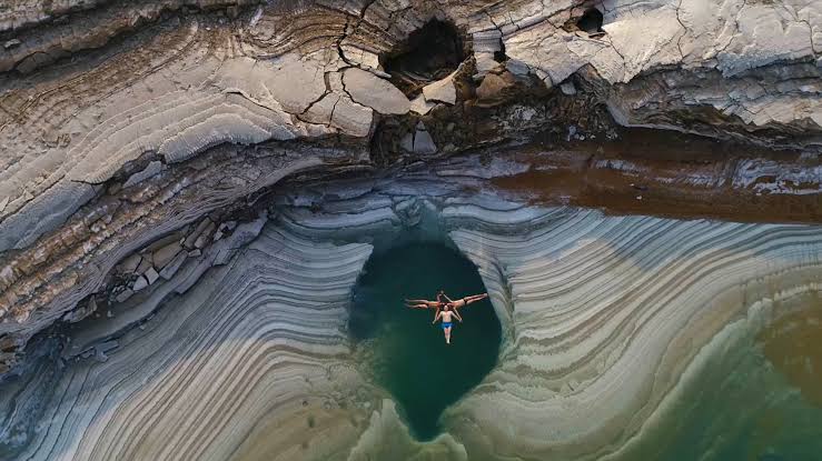
One of the most important tectonic structures in our region is the Dead Sea Transform Fault, historically associated with the broader African-Arabian rift system. The transform extends for roughly 1,000 kilometres from the northern Red Sea region toward southern Turkey and forms a major boundary between the Arabian Plate and the Sinai microplate. Its movement is predominantly left-lateral strike-slip, meaning the crust on one side moves horizontally relative to the other. Although the movement is measured in millimetres annually, its cumulative effects have shaped some of the most dramatic geological landscapes on Earth.
The Dead Sea basin is perhaps the most striking example. Its exposed shoreline lies more than 400 metres below sea level, making it the lowest land elevation on the planet. The surrounding terrain rises sharply toward the mountains of Jordan and the western highlands, creating an extraordinary contrast between deep tectonic depressions and elevated landscapes. These features are not simply scenic attractions. They are physical evidence of the enormous geological forces that have reshaped our region over millions of years.
Historical records document destructive earthquakes across Jordan, Palestine, Syria and Lebanon over many centuries. These events remind us that a fault does not need to produce frequent large earthquakes to represent a serious hazard. Geological strain may accumulate over periods longer than a human lifetime, leaving communities with little direct memory of destructive shaking. This is precisely why regional geological studies, historical earthquake records and modern monitoring systems must be considered together when assessing future risk.
Our understanding of how neighbouring faults interact is also evolving. When powerful earthquakes struck Turkey and Syria in February 2023, researchers investigated why the expected major rupture did not propagate along the Dead Sea Fault. Scientists from the University of Haifa and the Geological Survey of Israel challenged assumptions about the tectonic relationship between the East Anatolian and Dead Sea fault systems. Their findings suggest that the transmission of seismic energy between neighbouring fault networks is more complex than previously assumed.
Related reading: Why Turkey earthquakes don’t hit Israel? It’s the Dead Sea Fault
Turkey and Syria show what happens when geology meets human vulnerability

On February 6, 2023, the world witnessed the destructive power of tectonic stress when two major earthquakes struck southern Turkey and northern Syria. The first, measuring magnitude 7.8, ruptured along the East Anatolian Fault system, followed hours later by another earthquake measuring magnitude 7.5 on an adjacent fault. Tens of thousands of people were killed, more than 120,000 were injured according to figures examined in my research, and millions experienced displacement and disruption. Entire neighbourhoods were reduced to rubble as roads, hospitals and public infrastructure failed.
Satellite radar observations revealed horizontal displacement of several metres along sections of the ruptured fault system. Imagine two enormous blocks of the Earth’s crust suddenly moving sideways relative to each other, releasing energy that had accumulated over a long period. The resulting seismic waves travelled through the surrounding region, producing intense ground shaking and widespread structural damage. These observations give us a clearer understanding of the scale of the forces involved, but they also raise a more urgent question about the consequences for human settlements.
Why do some buildings survive powerful earthquakes while others collapse catastrophically? The answer depends on a combination of shaking intensity, ground conditions, structural design, construction quality and the enforcement of building regulations. An earthquake is a natural geological event, but the scale of a disaster is strongly influenced by human decisions made long before the ground begins to move. Poorly constructed buildings, inadequate reinforcement and failures in regulatory oversight can transform a hazardous event into a mass-casualty catastrophe.
The destruction of Antakya in southern Turkey demonstrates why rebuilding must involve more than reconstructing damaged buildings. The historic city suffered immense losses, forcing planners and engineers to reconsider questions of land safety, urban design, connectivity and community resilience. Proposals by Foster + Partners and collaborating Turkish organizations have emphasized the importance of rebuilding on safer land while preserving the city’s cultural and historical identity. I believe this integrated approach should become a model for disaster recovery throughout our region.
Related reading: Foster + Partners plan to rebuild Turkey earthquake devastation
The relationship between construction methods and earthquake casualties is especially significant in developing regions. Traditional materials such as earth, adobe and masonry can have environmental and cultural advantages, but buildings made from these materials require appropriate structural design and reinforcement to withstand severe shaking. In Iran, past earthquakes have demonstrated how vulnerable poorly constructed earthen buildings can be when intense shaking causes heavy walls and roofs to collapse. The lesson is not that traditional building materials must be abandoned, but that sustainability and seismic safety must be considered together.
Related reading: Iran’s Earth Buildings are the Leading Cause of Quake Casualties
Can earthquakes ever be predicted?

One of the most persistent questions in seismology concerns whether scientists will eventually be able to predict major earthquakes before they happen. We can identify active faults, measure tectonic movement and estimate the probability of earthquakes over long periods, but we cannot currently determine the exact day, hour and location of a future destructive rupture with reliable accuracy. This limitation is deeply connected to the complex behaviour of fault systems, where small changes in stress or friction can influence how ruptures develop. Even with modern instruments, the Earth’s crust remains an enormously complicated physical system.
Related: goats predict earthquakes in Sicily
An influential concept in earthquake science is Self-Organized Criticality, which describes how complex systems can evolve toward states where small disturbances may produce events of widely different sizes. Applied to earthquakes, this framework helps explain why a small rupture may remain localized while another develops into a much larger event. The interaction between geological structures, accumulated strain and fault friction creates behaviour that is difficult to forecast deterministically. The challenge is not simply that we lack enough instruments, but that the system itself involves complex and potentially nonlinear interactions.
At the same time, I believe scientific investigation should continue exploring whether changes in seismic behaviour might improve probabilistic forecasting. Researchers study repeating earthquake sequences, variations in seismic activity rates and the redistribution of stress between faults. Some fault segments appear to experience recurring ruptures with similar characteristics, while others exhibit irregular sequences that are much more difficult to interpret. These patterns may help scientists estimate long-term probabilities or recognize changes in regional seismic activity, even when precise prediction remains impossible.
One theoretical approach that interests me is Omega Theory, developed in research associated with Dr. Jure Žalohar. This framework draws on Cosserat continuum mechanics, which incorporates local rotations as well as translational motion when describing deformation in geological materials. It explores the possibility that interacting fault networks behave as coupled nonlinear systems in which strain changes and seismic activity can exhibit forms of synchronization. Researchers investigating such models examine whether patterns of increasing, decreasing or relatively constant seismicity might indicate changing probabilities of future ruptures.
These ideas deserve investigation, but they must be distinguished from established earthquake prediction methods. Omega Theory and related synchronization approaches have not demonstrated the ability to reliably forecast the exact timing and location of destructive earthquakes, nor have they replaced conventional seismic hazard assessment. Their value at present lies in exploring the physics of complex fault interactions and developing hypotheses that can be tested against observations. In science, a promising theoretical framework becomes useful for public safety only when its predictions can be independently tested and shown to perform reliably.
The same caution applies to proposed relationships between solar activity and earthquakes. Some studies have examined statistical correlations between sunspot cycles and seismic activity, including suggestions that certain regional earthquake patterns may occur after periods of low solar activity. However, a statistical association does not establish causation, and no convincing physical mechanism has demonstrated that solar cycles reliably trigger major tectonic earthquakes. The United States Geological Survey and other scientific authorities continue to identify tectonic stress accumulation and fault rupture as the principal causes of earthquakes.
Reading the past to understand the future

Because instrumental earthquake records cover only a short portion of geological history, scientists must also examine evidence from centuries before modern seismographs existed. Historical descriptions, archaeological damage, religious records, government archives and accounts of ground shaking can help reconstruct the location and intensity of past events. This field, known as historical macroseismology, is especially valuable in regions where destructive earthquakes may occur only once every several centuries. Without historical evidence, a quiet period can create a misleading impression of geological stability.
European earthquake records provide useful examples of this approach. Historical investigations of events in the Outer Western Carpathians in 1786 and the Sudetes in 1901 have helped researchers study seismic activity in regions not usually associated with frequent major earthquakes. The 2004 Kaliningrad earthquakes, which reached magnitudes of approximately 5.0 and 5.2, similarly demonstrated that significant shaking can occur in areas considered to have relatively low seismic activity. These examples remind us that the absence of recent disasters is not proof that geological risks have disappeared.
For the Levant, historical records must be combined with geological trenching, sediment studies, fault mapping and modern geodetic observations. Earthquake recurrence is rarely as regular as a calendar, and estimating future hazard requires understanding both the rate of tectonic movement and the history of past ruptures. It is possible to identify regions of concern without claiming to know exactly when the next major event will occur. That distinction is essential for communicating risk responsibly to governments and the public.
Another important dimension of geological vulnerability is the interaction between natural hazards and human environmental activities. In Iran, excessive groundwater extraction has caused significant land subsidence in several regions, damaging roads, buildings and essential infrastructure. Although subsidence and earthquakes are different processes, weakened ground and damaged foundations can increase the vulnerability of communities already exposed to seismic hazards. I believe this illustrates why water management, environmental planning and geological risk assessment cannot be treated as entirely separate disciplines.
Related reading: Iran is sinking in sinkholes from overwatering
Building resilience before the next earthquake

Although we cannot prevent earthquakes, we already possess powerful technologies for reducing their consequences. Modern seismic monitoring networks detect ground motion, high-precision GPS instruments measure subtle crustal deformation, and computer models combine geological information with infrastructure and population data to estimate potential damage. These systems allow scientists and emergency planners to identify vulnerable areas and develop more effective response strategies. The real challenge is ensuring that this knowledge reaches the institutions and communities responsible for making decisions.
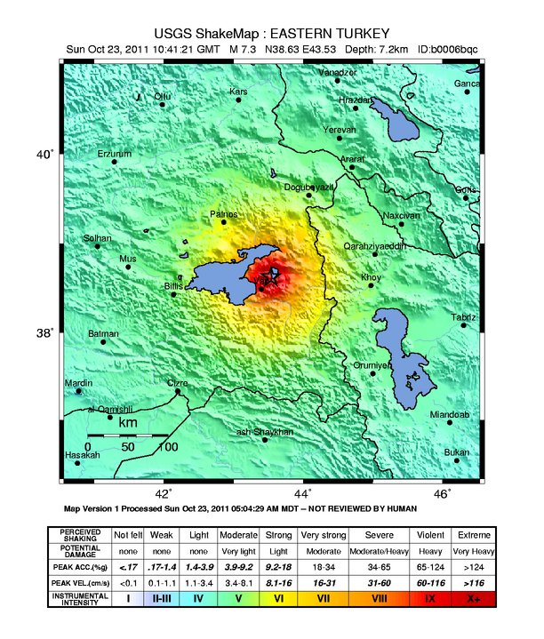
In the United States, the National Earthquake Hazards Reduction Program provides an example of how scientific research, engineering and government coordination can contribute to disaster resilience. Technologies such as ShakeMap generate estimates of ground shaking shortly after an earthquake, helping responders identify severely affected areas. HAZUS loss-estimation software combines geographical data, building characteristics and population information to estimate potential casualties, economic losses and emergency shelter requirements. These are practical applications of scientific knowledge that can improve planning before a disaster and coordination afterward.
Earthquake early warning systems offer another important advance, although they are sometimes misunderstood. They do not predict an earthquake before it starts. Instead, sensors detect the initial seismic waves generated by a rupture and transmit alerts before stronger shaking reaches locations farther away. Depending on the distance from the earthquake and the speed of communications, these warnings may provide several seconds to tens of seconds for protective actions.
Even a few seconds can make a difference. Automated systems may slow trains, isolate gas supplies, stop elevators at safe floors or alert people to protect themselves. However, warning systems cannot substitute for safe buildings, especially in locations very close to an earthquake’s epicentre where little or no warning may be available. Their effectiveness depends on reliable monitoring networks, clear public communications and regular preparedness education.
Structural engineering remains one of our strongest defences. Modern seismic building codes are designed to reduce the likelihood of catastrophic collapse, while retrofitting can strengthen vulnerable concrete and masonry buildings that were constructed before current standards were adopted. Governments must prioritize the enforcement of these requirements, particularly in rapidly growing urban areas where construction pressure can encourage shortcuts. A well-designed building may still suffer damage during severe shaking, but its ability to protect the people inside can determine whether an earthquake becomes a tragedy.
We must also consider what happens after the shaking stops. Hospitals, water systems, emergency communications and electricity supplies are all essential to recovery, and their failure can intensify a humanitarian crisis. Decentralized renewable energy technologies can provide valuable support when conventional electricity networks are damaged, particularly in isolated communities and temporary shelters. Engineers in Turkey have developed a portable, foldable solar power system intended to provide electricity in disaster zones, illustrating how environmental innovation can become part of emergency response.
Related reading: A new foldable, moveable 15kW solar power plant for disaster zones
At the household level, preparedness should become as familiar as other basic safety practices. Heavy furniture and water heaters should be secured, emergency supplies should include drinking water, non-perishable food, first-aid materials and lighting, and families should understand the safest actions to take during strong shaking. In many settings, the recommended response is to drop, cover and hold on rather than run outside where falling masonry and debris may create additional dangers. Local civil defence authorities should provide guidance suited to the construction and conditions of each community.
For Jordan and neighbouring countries, these measures require cooperation across government agencies, universities, engineering institutions and local communities. Geological hazards do not recognize national borders, and the scientific knowledge needed to understand them should not be confined by political divisions. Shared monitoring data, regional research, engineering standards and emergency preparedness initiatives can help reduce vulnerability across the entire Levant. The same tectonic systems connect our landscapes, and understanding those systems can provide a practical foundation for collaboration.
Learning to live on a moving planet
Earthquakes remind me that the Earth is not the fixed and permanent foundation we often imagine. The mountains, valleys and coastlines around us are products of continuing geological change, shaped by processes operating on timescales far beyond our own. The Dead Sea basin, the great fault systems of the Middle East and the destructive earthquakes experienced across our region are different expressions of the same planetary dynamics. We live on a world whose internal energy is constantly reshaping its surface.
The appropriate human response is neither helplessness nor fear. We should continue investigating the complex physics of earthquakes, including emerging theories about fault synchronization, while recognizing the limits of current forecasting technology. At the same time, we must apply the scientific knowledge already available to improve construction, strengthen essential infrastructure, develop effective warning systems and educate communities. Scientific advancement is meaningful when it reduces human vulnerability rather than simply increasing our ability to describe natural phenomena.
I believe earthquake resilience must become an integral part of sustainable development in the Middle East. We cannot claim to be building sustainable cities if their hospitals, schools, homes and water systems remain unnecessarily vulnerable to foreseeable geological hazards. The future of regional development depends not only on how efficiently we use energy or water, but also on how intelligently we respond to the physical environment in which we live.
We cannot command the movement of tectonic plates or determine when their accumulated energy will be released. But we can decide whether our buildings are safe, whether our institutions are prepared and whether our communities understand the risks beneath their feet. The Earth will continue to pulse, shift and evolve long after our lifetimes. Our responsibility is to learn how to live safely and wisely upon it.
Dr. Osama Gazal is a hydrogeological and environmental applied engineering expert from Jordan.