
The most striking feature of Israel’s landscape is its variety. This tiny area has a dramatic desert in the South and the green Galilee mountains in the North. Two areas that are so different, but you can drive from one to the other in less than 3 hours.
Israelis love their country and love to walk its trails. The countryside is crisscrossed with an impressive network of clearly waymarked and maintained trails, covering the entire country. The combination of the pleasant weather outside the summer months, terrain that is not too rough and the solid infrastructure makes the county a great destination for hiking loving families.

DAY 1
A great place to start is the “Yehudiya Forest Nature Reserve” (GPS 32.941606, 35.701637) in the Golan Heights. The Golan is a flat high plateau that drops steeply towards the sea of Galilee and the Hula valley. The soil is mostly basalt rocks originated from ancient volcanic activity. The result is a series of gorges with waterfalls, pools and water that flow all year round. Yehudia Nation park includes the 3 biggest and most attractive streams of the Golan heights. The Yehudiya, Meshushim and Zavitan streams. There is a large selection of trails to pick from ranging from very short up to 10 Km long. The reserve includes some of the best trails and some of the most beautiful pools in the Golan Heights.
DAY 2
Just about 1/2-hour drive south-west and we arrive at the Sea of Galilee. The lake marks the border between the Golan Height rising from its east coast and the Galilee mountains rising from the west. One of the classic hikes in northern Israel is to hike from the lake to the summit of Mount Arbel. Mount Arbel’s height is only 180 meters but is one of the most famous mountains in Israel. It rises very steeply, 380 meters from the Sea of Galilee and is considered by many the best view-point around the lake. From the summit, there is an amazing vista that includes most of the Galilee mountains, the Golan Heights and famous landmarks like Tiberias, Safed and the Horns of Hattin. The trail head is near the village of Hamam at (GPS 32.827706, 35.492245). It’s an 8 Km moderate circular trail. Besides the great view from the summit the route will bring you to the Arbel cliff fortress and the ruins of a 4th century synagogue.
DAY 3
We are heading now 2 hours west towards the Mediterranean coast to Dor-Habonim nature reserve. GPS (32.642601, 34.924917). The 5 Kilometers strip that connects Moshav Habonim and Kibbutz Dor, is regarded by many people as the most beautiful coastal area in Israel. Additionally, it is very diverse. In this short distance it is possible to see marvelous small coves, an archeological site, an old ship wreck and the “Blue Cave”. There are several easy and flat trails to choose from between and 2 and 8 Km.
DAY 4
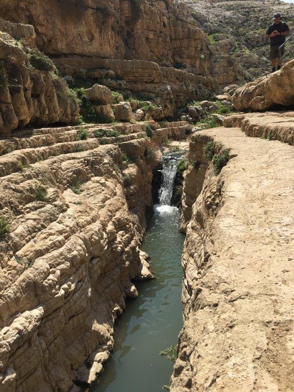
We continue our journey to Jerusalem (About 1.5 hours’ drive). Jerusalem is an amazing city for any tourist. It has something for everyone: History, Archeology, Arts, architecture, Night life, shopping and much more. But the fact that Jerusalem is also a great Hiking Hub comes as a big surprise to most people. While hiking is by no means the reason for visiting this great city, for a nature lover, to mix a day of hiking in between the city many attractions can be a great way to Spice-Up his visit. Less than 30 minutes’ drive east you will arrive to Wadi Qelt (Prat Stream) GPS (31.831305, 35.306738), Which is one of the most popular and rewarding hikes around Jerusalem. Wadi Qelt is a stream runs from the northwestern slopes of the Judaean Desert just outside Jerusalem and down to the city of Jericho. It’s one of the biggest and only sources of running water in the Judean Desert. The area has a long human history. While hiking you will pass ancient aqueducts and old monasteries. The deep canyon is full of springs, poos and waterfalls. A real oasis!! There are many variations for all hiking levels ranging from 3-20 km.
DAY 5
150 Km south and we arrive to the Negev desert. The Negev desert is the largest geographical area in Israel and offers a huge variety of hiking options. One of the best areas is the Zin valley at the Foot of Midreshet Ben-Gurion. GPS (30.850787, 34.778326). There are two very popular circuits. The tougher, 17 Km long, visits the magical desert spring of Ein Akev and the summit of “Hod Akev”, one of the most rewarding view points in the Negev. The easier but also beautiful option is Ein Avdat spring. There are several variations to choose from between 3-10 km.
DAY 6
Less than half an hour drive south, we arrive to Mitspe Ramon GPS (30.613430, 34.803775), situated on the edge of the Ramon Crater (Makhtesh). “Makhtesh” is a unique crater-like formation created by erosion. There are only 7 such craters in the world, all of them located in the Land of Israel (5) and the Sinai desert (2). Any hiker visiting Israel should include at least one of them in his itinerary. Ramon Crater is the largest Makhtesh in the world. Over 40 km long, 10 km wide and about 400 m deep. There are dozens of hiking trails in and around the crater to keep any hiker busy for a few days.
DAY 7
Two hours’ drive further south and we reach the touristic city of Eilat. The city is full of tourist attractions and restaurants, but it is also a great hiking hub. Within a short drive from the city you can find amazing desert hiking options. What makes the Eilat Mountains range unique is the contrast of colors. The sand and rocks change sharply between Black, Yellow and Red and in the horizon, you have in view the Edom reddish mountains and the deep Blue of the Red sea. Also here, there are countless options for all levels. Starting from the classic and easy “Red Canyon” (GPS 29.669201, 34.870346) hike up to tough deep desert tracks.
Visit “Israel by Foot” website for more Detailed descriptions and Hiking maps.


