
Commercial and private real estate development in the United Arab Emirates threaten whales, dugongs, coral reefs and all marine life in the Arabian Gulf. Now some 80 regions in the Arab world are being tracked by satellite to show us how much environmental destruction happening is man-made.
See the photo above and what has changed in the UAE in just 10 years, from 1999 to 2009. Consider the building projects in the UAE: with artificial islands and archipelagos, such as The World and Palm Island projects off the coast of Dubai.
The progress of the UAE’s rapid development during the past two decades has recently been documented by the UN Environment Program, which has examined the changes at more than 80 locations using historical photographs and satellite images.
Their new “Atlas” project not only shows us stark images, it is suggesting ways that we can repair the earth.
Stark photos and before and now images give light to the rate of development and wide-ranging change in land use, urban growth, and depletion of marine and coastal areas.
Loss of natural habitat has been characterized by altered and shrinking coastal water areas, loss of wildlife habitats; and the impact of climate change in the UAE, the UN has found. But the study looked well beyond the UAE to regions in Morocco, Egypt, and even the Palestinian Authority.
The UN’s Atlas uses a combination of on-the-ground photographs, current and historical satellite images, with a narrative based on extensive scientific evidence.
The Atlas studies clearly demonstrate the pace of development in the region, offering compelling examples of wide-ranging environmental change, including land use change, urban growth, degradation of marine and coastal areas, altered hydrology and shrinking water bodies, loss of habitats and impacts of climate change.
The Atlas images serve to highlight the distinctive environmental circumstances and challenges faced in the Arab region, from limited freshwater resources, rapid urbanization, depletion of natural resources, and the vulnerability of many Arab settlements to environmental risks and natural disasters.
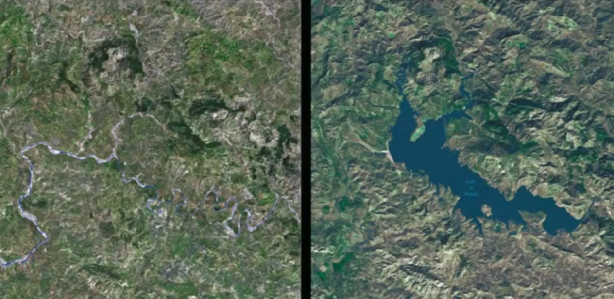 Dammed river in Morocco, for hydropower, before and after
For example, water scarcity is a key environmental issue in 19 of the 22 countries. Very low and highly variable annual rainfall makes the region particularly vulnerable to climate change impacts, and per-capita water availability is expected to halve by 2050. Coupled with increases in temperature, these changes will intensify pressure on natural and physical systems.
Desertification and land degradation afflicts 17 of the countries, placing limited arable lands at further risk (only 14.5 per cent of the total land area is arable). This can cause transboundary issues such as food insecurity and human migration.
Biodiversity is declining due to habitat degradation and loss. The total number of known threatened species in the region stands at 1,746, with a majority of them critically endangered.
Many of these major issues are interrelated and most are a direct consequence of increasing populations and environmental conditions associated with climate change.
Additionally, the Arab region is subject to a variety of natural hazards—the arid to hyper-arid climate lends itself to frequent drought, which is the region’s most-pressing natural hazard.
Consider that between 1980 and 2008, droughts, earthquakes, floods and storms affected more than 37 million people in the region and caused damage estimated at US$20 billion.
 Coastal erosion of the land around the tip of the Nile, 1968 to 2005. Some 16 square kilometers of land is lost from development over this time
The Arab region has faced 276 disaster events in the past 25 years and more than 40 per cent of these natural disasters occurred in the past five years.
The Atlas brings to light stories of these environmental changes through images showing visual evidence of changes taking place in the land, water and atmosphere, and covering trans-boundary issues like river basins, transboundary conservation areas and pollutants.
It also illustrates how humans have positively or negatively altered their surroundings and continue to make observable and measurable changes to the Arab region and its environment.
Although the challenges depicted are striking, the atlas examines the opportunities that these challenges present, as well as some of the innovative responses that are being implemented in the region.
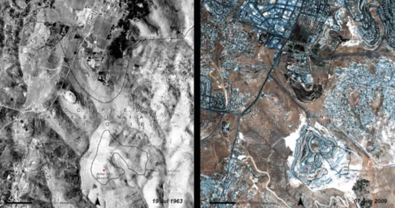 Development on a mountain in the West Bank, Palestinian Authority, 1963 to 2009
For example, many Arab nations have established special institutions for environmental management and sustainable development, and improvements in health and education create building blocks for accelerating this sustainable development.
The Atlas also sheds light on the unique environmental issues faced by each country, and tracks the individual progress each is making towards achieving the goal of Ensuring Environmental Sustainability, as part of the United Nation’s Millennium Development Goals.
The Atlas is the latest addition to a series of atlases coordinated by UNEP that began in 2005 with the launch of a global atlas – “One Planet, Many People.”This new atlas is an important addition to the growing suite of UNEP atlases that aim to contribute to a better understanding of the dynamics of environmental change.
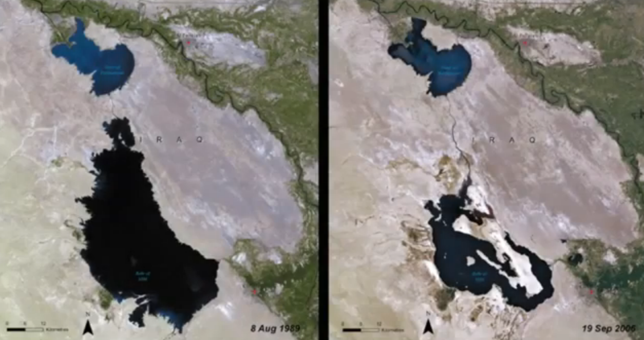 Inland lake in Iraq, from 1989 to 2006
With nearly 140 paired satellite images showing change over time in each of the Arab countries, the Atlas provides visual evidence of sometimes drastic change occurring in the region over a relatively short span of years.
Landscape changes that are noteworthy and common to many of the countries include: the greening of the desert and increased irrigated agriculture; expansion of oil fields; deforestation and vegetation loss, insect infestations or harvesting for fuelwood; unchecked urbanization, development of coastal areas and impacts from severe weather events.
The rise of megacities
The development of countless mega-cities in the Arab region is one of the most striking impressions the atlas provides. Cairo, Algiers, Beirut, Casablanca, Amman, Sana’a, Riyadh have all experienced extensive and rapid development of their urban areas.
Coastal developments such as Mesaieed Industrial City (Qatar), Aden (Yemen), and Qatif and Tarut Islands (Saudi Arabia), have transformed the coastal and marine environments, with at times, grave consequences (oil pollution, destruction of coral reefs, mangroves and seagrass ecosystems).
(Related: Qatar must stop development to save mangroves)
The greening of the desert shown in Al Ain (UAE) and the Kuwait-Iraq Separation Border displaying Kuwait’s conservation and resource protection are testament to efforts in the region to improve environmental conditions and conserve water resources.
Wafra Farms in Kuwait has expanded their food production to include aquaculture of Nile tilapia in order to supplement the fish industry, and has established greenhouses to improve crop production.
Greenhouse agriculture has been implemented at a large scale in Syria—the growth of this controlled agriculture was catapulted by recurring drought, the need to improve agricultural efficiency and to meet increased demands for food production internally and abroad, nevertheless with possible environmental impact.
The Taparura Project in Sfax, Tunisia, is a poignant example of projects that are being launched in the region to revive urban areas and reintegrate their coastlines.
Perhaps the most compelling story of environmental change is the revitalization of the Mesopotamian Marshlands, which suffered a tragic loss of wetlands from 1950 through 1990, nevertheless keeping up the positive development has been a challenge
The images from the Jiyeh Power Plant bombing in 2006 and its resultant oil spill in Lebanon and the oil fires in Kuwait as a result of the 1990 invasion by Iraqi forces, vividly show the environmental impacts of conflict.
It’s not hard to find our own photos on Google, ones that take us back to back then, the 1960’s (see below). We can see a very different landscape in places like Dubai and Abu Dhabi in the period before the massive buildings and island projects were begun.
 One British lady, Margaret Holmes, who has been living in Dubai for more than 18 years, told The National in the UAE: “Dubai felt very small when we first came but it’s become a sprawling metropolis now as well as a place people look to for its forward thinking and rapid development.”
Although Ms. Holmes lauded the progress that has been made, including “places to go to like parks and shopping malls,” she did not mention anything about the impact this development has had on the local environment, including severe shoreline erosion and danger to area marine and other wildlife.
The UAE images shown in the UN’s work ‘The Atlas of Our Changing Environment‘ show the pace of modern development and wide-ranging landscape changes, including diminishing fresh water, rapid urbanization, depletion of natural resources and the vulnerability of many towns and cities to environmental risks and natural disasters such as severe storms.
More sustainable development is needed in locations like Dubai.
They should model themselves on other UAE locales like Abu Dhabi, which tries to be involved in more sustainable development.
Link to Atlas is here
Read more about development and impact on the environment:
The Lagoons – Another Waterfront Development for Dubai
Futuristic Dubailand Theme Park City Going Ahead With $55 Billion
Another Sustainable Development Report from Abu Dhabi
Coastal Erosion Threatens Evolutionary Hotspots in Gulf Region
Photo of Old Dubai in 1965 by Marble Eco Systems; other images as screengrabs from the UN Atlas project video

Author: Maurice Picow
Maurice Picow grew up in Oklahoma City, U.S.A., where he received a B.S. Degree in Business Administration. Following graduation, Maurice embarked on a career as a real estate broker before making the decision to move to Israel. After arriving in Israel, he came involved in the insurance agency business and later in the moving and international relocation fields. Maurice became interested in writing news and commentary articles in the late 1990’s, and now writes feature articles for the The Jerusalem Post as well as being a regular contributor to Green Prophet. He has also written a non-fiction study on Islam, a two volume adventure novel, and is completing a romance novel about a forbidden love affair. Writing topics of particular interest for Green Prophet are those dealing with global warming and climate change, as well as clean technology - particularly electric cars.


Obviously, human development has left its environmentol imprint in other parts of the world as well. But the rate it has been occurring in the Middle East (where fresh water and natural wildlife habitats are scarace) gives even more emphasis on the direction our planet is heading.