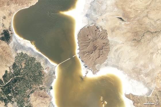
The most recent satellite image of Iran’s Lake Urmia demonstrates how drastically the lake has shrunk since 1998!
Last year an Iranian activists were beaten for protesting government projects that are detrimental to Lake Urmia – the largest landlocked salt lake in the country. Before and after images captured by the Thematic Mapper on NASA’s Landsat 5 satellite demonstrate how the lake shrunk 4 meters between August 25, 1998 and August 13, 2011, which doesn’t bode well for the 76 million people who live within its 500km radius. Recently the Center for Climate and Security warned that policymakers should pay closer attention to this environmental hazard as its unmitigated unfolding could further compromise the country’s “economic health and stability.”

The rocky outcrop in the middle of the lake was once an island. Now it’s just an extension of land. Also notice the difference in color in the later image, which is a result of rising sedimentation and salinity.
Lake Urmia is fed by 60 rivers and streams that deposit salts that have crystallized on the lakeshore as a result of increased evaporation, unravelling its fragile ecosystem.
According to a 2007 study, 65% of the lake’s decline can be attributed to climate change that has altered inflows, while 25% is linked to damming projects and another 10% to decreased precipitation.
Amin Eimanifar, lead author of the study, called Lake Urmia a “hungry saline lake.”
Residents and activists are concerned that falling water levels and rising salinity will collapse the food-chain, alter the local climate, and cause windblown “salt-storms” that would be damaging to human health. Nearby agricultural fields are also at risk of contamination.
If this happens, the 6.4 million who live within the lake’s direct vacinity could lose their livelihood, which will have a ripple effect on the rest of the country.
Although we tread carefully where Iranian political rhetoric is concerned, these satellite images make it very clear that Lake Urmia is heading in a very unhealthy direction, one that should cause grave concern among Iranian government officials.
More on Lake Urmia and Iran:
Police Beat, Tie-Up, and Fire on Citizens Protesting Against Dying Lake in Iran
Saltier Than the Dead Sea, Lake Orumiyeh is in Trouble
Iranian Citizens Fight Smog With Tehran Monoxide Project


What are we doing?? It is some kind of Global Disgracing…
Hello,
These are nice picture showing the depth of disaster in Urmia Lake. I would be grateful if some one could send me the latest picture of Urmia Lake.
Dr. Naser Agh
Urmia University
Not only shrunk but it looks like it is full of silt and pollution. It’s a completely different color. What a disgrace.