 From urbanisation in Morocco to lake shrinkage in Iran, these shocking NASA photos prove how this region is in dramatic ecological flux.
Unless you have been living in a consumer-induced coma, it will not have escaped your attention that the world is under serious environmental stress. And a large chunk of that stress has been human-induced. Whilst the exact influence of human behaviour is hard to measure, the carbon we keep pumping into the atmosphere is definitely not helping.
Indeed we are seeing more floods, droughts, melting ice, desertification and a continued gutting of our seas. The Middle East is no different and NASA has the pictures to prove it. So brace yourself – this is not going to be pretty.
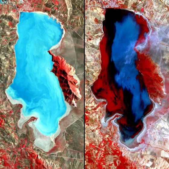
Lake shrinkage in Iran
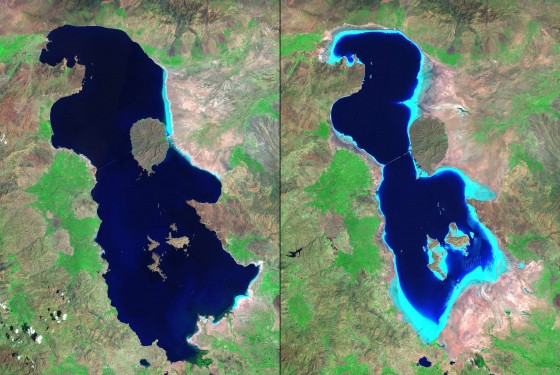
Left: August 1985. Right: August 2010.
Iran’s Lake Oroumeih (also spelled Urmia) is the largest lake in the Middle East and the third largest saltwater lake on Earth. But dams on feeder streams, expanded use of ground water, and a decades-long drought have reduced it to 60 percent of the size it was in the 1980s. Light blue tones in the 2010 image represent shallow water and salt deposits. Increased salinity has led to an absence of fish and habitat for migratory waterfowl. At the current rate, the lake will be completely dry by the end of 2013.
Images taken by the Thematic Mapper sensor aboard Landsat 5. Source: USGS Landsat Missions Gallery, U.S. Department of the Interior / U.S. Geological survey.
Urban Growth in Morocco
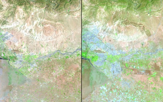
Left: July 2, 1985. Right: June 24, 2011.
The Moroccan cities of Agadir, Inezgane and Tikiouine are close to the Atlantic coastline (seen in blue in the images), and stretch into the foothills of the Atlas Mountains. Agadir was nearly destroyed by an earthquake in 1960. Reconstruction has focused on tourism, turning this area into a winter destination. The 1985 image shows the area 25 years into the rebuilding. By 2011, the urban areas reach into the Sahara Desert. Growth has been influenced by the expanding fishing industry and modern commercial ports.
Images taken by the Thematic Mapper sensor onboard Landsat 5. Source: USGS Landsat Missions Gallery, “Urban Growth in Morocco, 1985-2011,” U.S. Department of the Interior / U.S. Geological Survey.
Oil fires of War in Kuwait
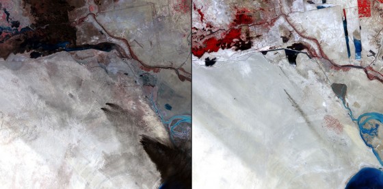
Sabriyah Oil Field, Kuwait. Left: February 2, 1991. Right: July 15, 2011.
Iraqi forces set hundreds of oil wells ablaze during the US-led Gulf War following Iraq’s invasion of Kuwait in 1991. Some six million barrels of oil per day went up in smoke. Residue darkened the normally light-colored soil, as seen in the 1991 image. By 2011, the environment has largely recovered. Smoke plumes in the latter image are from fires normally set to burn off gases from the wells.
1991 image taken by the Thematic Mapper sensor aboard Landsat 5. 2011 images taken by the Enhanced Thematic Mapper Plus aboard Landsat 7. Source: USGS Landsat Missions Gallery, U.S. Department of the Interior / U.S. Geological Survey.
Agricultural Growth in Saudi
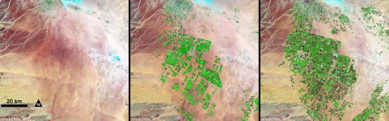
Only a few centimeters (about one inch) of rain falls in the Saudi Arabian desert each year, but crops still grow thanks to aquifers deep below the surface, which contain water trapped during the last Ice Age and rainwater that fell over several hundred thousand years. Saudi Arabia drills through the desert floor and irrigates the fields with a circular sprinkler system known as center-pivot irrigation.
Hydrologists estimate that it will be economical to pump this water only for about 50 more years. In these images, the agricultural fields are about one kilometer (0.62 mile) across. Healthy vegetation appears bright green while dry vegetation looks orange. Barren soil is dark pink and urban areas, like the town of Tubarjal at the top of each image, are purple.
Images taken by the Thematic Mapper sensor onboard Landsat 4 and 5, and the Enhanced Thematic Mapper Plus sensor onboard Landsat 7. Source: NASA/Aries Keck, Goddard Space Flight Center.
Lake degradation in Tunisia
Ichkeul Lake, northern Tunisia. Left: November 14, 2001. Right: July 29, 2005
Although the water level in lake Ichkel is higher, a large part of the lake appears red due to the presence of aquatic plants. Ichkeul Lake and wetlands are a major stopover point for hundreds of thousands of migrating birds who come to feed and nest. It is the last remaining lake in a chain that once extended across North Africa, and has badly deteriorated as a result of the construction of three dams on rivers supplying it and its marshes, which have cut off almost all inflow of freshwater. The Tunisian government plans to undertake various measures to retain freshwater in the lake on a year-round basis and reduce the salinity of the lake.
Images taken by the Advanced Spaceborne Thermal Emission and Reflection Radiometer (ASTER) onboard NASA’s Terra satellite. Credit: NASA/GSFC/METI/ERSDAC/JAROS and the U.S./Japan ASTER Science Team. Source: the ASTER gallery.
The impact of dams in Turkey
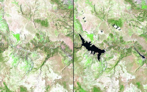
Goksu River basin, southeastern Turkey. Left: July 11, 1987. Right: July 13, 2011.
In 1990, a series of seven dams was started in the Goksu River basin to provide long-term hydroelectric power to the region. Government officials and others are using Landsat satellite data to monitor the growth and impact of these dams, since the Goksu is one of the few remaining free-flowing rivers in Turkey. The Gezende dam, completed in the early 1990s, reduced flow downstream and significantly affected aquatic species, while construction of the Ermenek dam in the early 2000s created a large reservoir that flooded fragile wildlife habitat.
Images taken by the Thematic Mapper sensor aboard Landsat 5. Source: USGS Landsat Missions Gallery, “Goksu River Dam Project,” U.S. Department of the Interior / U.S. Geological Survey.
The Dead Sea’s Water
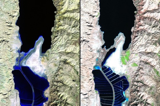
Left: November 9, 1984. Right: November 28, 2011.
The Dead Sea is one of the world’s saltiest bodies of water, too salty to harbor any life other than bacteria. Minerals from the sea, however, are extracted for various industrial purposes. Mineral evaporation ponds have replaced open water in the southern part of the sea, as can be seen in the 2011 image. In recent decades, the Dead Sea has shrunk as water has been diverted from the Jordan River, the sea’s main tributary. A plan has been announced to replenish the Dead Sea by building a canal from the Red Sea, providing fresh (desalinated) water to Jordan en route.
1984 image taken by the Thematic Mapper sensor onboard Landsat 5. 2011 image taken by the Enhanced Thematic Mapper Plus sensor onboard Landsat 7. Source: USGS Landsat Missions Gallery, “The Dead Sea,” U.S. Department of the Interior / U.S. Geological Survey.
Urban Sprawl in Saudi’s Capital
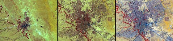
The Saudi Arabian capital. Left: 1972. Middle: 1990. Right: 2000.
Over time the population of Riyadh has soared from about half a million to more than two million. In the early 1970s, three times as many Saudi Arabians lived in rural areas as in cities. By 1990, the ratio had reversed — cities held three times as many as the rural regions.
Images taken by the Advanced Spaceborne Thermal Emission and Reflection Radiometer (ASTER) instrument. Courtesy of NASA/GSFC/METI/ERSDAC/JAROS and the U.S./Japan ASTER Science Team.
Agricultural growth in Libya

Left: January 13 to April 28, 1987. Right: March 25 to April 3, 2010.
With among the least renewable water of the North African countries, Libya relies on groundwater to meet 95 per cent of its water needs. In the 1960s, the discovery of water in deep aquifers under Libya’s southern desert inspired an enormous water transfer scheme — the Great Man-Made River Project, one of the largest civil engineering enterprises in the world. These images show the increase in irrigation in the Murzuq Basin in southeastern Libya made possible by water drawn from the east and northeast Jabal Hasaouna well fields.
Source: United Nations Environment Programme (UNEP). Taken from the Africa Water Atlas (2010); Division of Early Warning and Assessment (DEWA) UNEP, Nairobi, Kenya.
Lake Shrinkage in Egypt
Toshka, Egypt. Left: September 13, 1984 to September 29, 1987. Center: August 23 to September 1, 2000. Right: March 21 to 28, 2010.
In the mid-1990s, excess water was channeled from the Lake Nasser reservoir on the Nile River to the Toshka Depression in the Western Desert, creating a series of lakes. This “New Valley Project” was to relieve overcrowding within the Nile Valley and boost the economy. Despite soil poorly suited to irrigation, the area produced grapes, cantaloupes, tomatoes, cucumbers, citrus fruits and wheat. But Lake Nasser water levels fell after 1998 and flow to Toshka ceased in 2001. At the current rate of decline, the new lakes will be lost to evaporation within the next few years.
Source: United Nations Environment Programme (UNEP). From Africa Atlas of our Changing Environment (2008); Division of Early Warning and Assessment (DEWA) UNEP, Nairobi, Kenya.
For more on the changing climate of MENA see:
Middle East Water Woes Beg for Environmental Sewage Solutions
How NASA Sees the Changing Middle East Landscape
Middle East Illusions Change Reality

Author: Arwa Aburawa
Arwa is a Muslim freelance writer who is interested in everything climate change related and how Islam can inspire more people to care for their planet and take active steps to save it while we can. She is endlessly suspicious of all politicians and their ceaseless meetings, especially as they make normal people believe that they are not part of the solution when they are the ONLY solution. Her Indian auntie is her model eco-warrier, and when Arwa is not busy helping out in the neighborhood alleyway garden, swap shopping or attempting fusion vegetarian dishes- with mixed success, she’d like to add- she can be found sipping on foraged nettle tea.


The carbon issue is bogus, but legitimate environmental concerns based on other than people’s best interests are also wrong. Growth is taxing on the planet, and all things degrade, not improve with the passage of time. Any fool should know that. Alarmists are not appreciated by a knowing mankind and I trust that, other than ‘carbon footprint’ information, your information is useful. Carbon was, and remains a minuscule adverse factor of our universe. Wake up and stop counting beans; rather, fix some rice and warm tortillas to have with them.